ArcGIS Web Editor is a data editing application in ArcGIS Enterprise that streamlines data maintenance workflows. Web Editor provides a straightforward approach to editing for GIS and non-GIS users. The wide array of editing tools can be used for complex editing workflows.
Web Editor allows you to do the following:
- Create new features.
- Update existing features.
- Delete features.
- Create and update feature attributes.
- Edit vertices.
- Split, merge, move, and reshape features.
- Copy and paste features.
- Manage versions for versioned datasets.
- Edit utility networks.
Open Web Editor
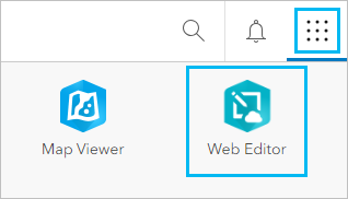
To open Web Editor, sign in to your ArcGIS Enterprise portal and choose Web Editor from the app launcher menu.

Note:
If Web Editor is not in the app launcher menu, it may mean you do not have the necessary licensing to use Web Editor.
Web Editor interface
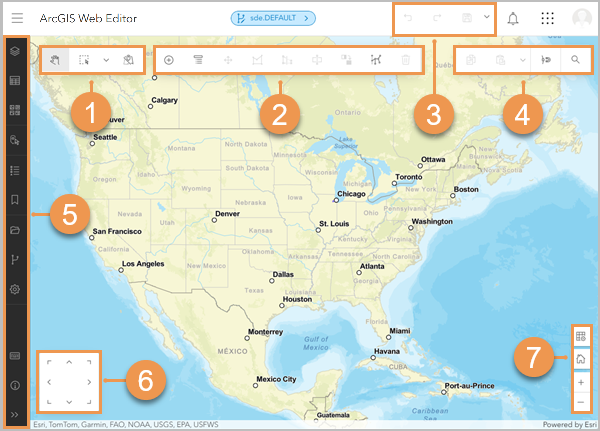
The Web Editor interface includes the main components shown in the image below and listed in the table below. The numbers in the image correspond to the numbers in the table.

| Label | Component | Description |
|---|---|---|
| Selection toolbar | The selection toolbar includes tools to pan the map and make selections. |
| Editing toolbar | The editing toolbar includes tools to create and modify features. |
| Header toolbar | The header toolbar includes tools to undo, redo, save, and discard edits. The header tools are available when editing a versioned dataset or using the drawing tools. |
| General toolbar | The general toolbar includes additional tools that are important for completing an editing workflow. |
| Contents (dark) toolbar | The Contents (dark) toolbar is used to manage and view key components of the map, including opening a web map, changing map settings, and viewing map layers. To access links to additional resources, click Information |
| Directional pad | The directional pad can be used to pan the map when the pointer is being used to create or modify features. The directional pad can be turned on or off from the Settings pane. |
| Zoom tools | The zoom tools can be used to zoom the map in and out or return to the home extent when the pointer is being used to create or modify features. |
Resources
Use the following resources to learn more:


 .
.
